
How to Use Sanborn Fire Insurance Maps for Family History
Sanborn Fire Insurance Maps are one of the sharpest tools in the genealogist’s toolbox. If you’ve ever wanted to know how to find them, how to read them, and how to incorporate them into your family history research, this article is for you.
What are Sanborn Maps?
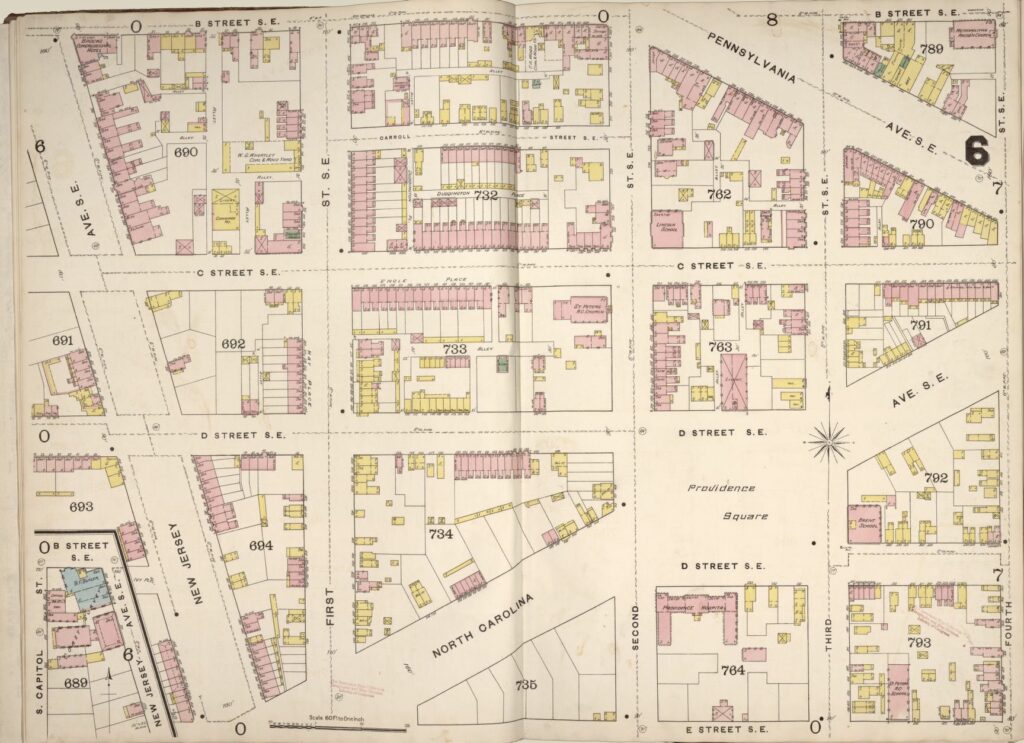
A Sanborn fire map is a sheet map or atlas map depicting the built environment of a city. A fire insurance map thoroughly describes buildings, land use, and transportation infrastructure, unlike a street map.
Fire insurance became an essential thing in the 19th century. Cities grew rapidly, and the structures started getting larger, more numerous, and taller than ever. But with this progress came changes in property law, not to mention a greater risk of raging fires breaking out.
When did Sanborn maps start?
The first American fire insurance maps were printed off and distributed in 1866. The format was created to aid in several ways. Among these were to aid in complying with newly enacted law and to help fire insurance companies determine the threat of fire in particular areas of town.
Who made Sanborn maps?
Daniel Alfred Sanborn made Sanborn maps. There were other published insurance maps, but Sanborn’s maps became the authority. They were published for close to a century, ending in the seventies.
How often were Sanborn maps made?
Some big cities like Chicago and New York would sometimes publish a new map every five years. Mid-sized cities could probably expect a new map about every ten years.
How do I use Sanborn maps?
Sanborn Maps provide genealogists and researchers with a unique map view that shows the layout and the internal construction of the buildings. They are also unique in that they’re pretty easy to read if all you seek is residential information.
Street numbers are marked as are block and lot numbers. Some Sanborn maps even feature Public Land Survey System boundaries.
It is also relatively easy to directly read information about businesses, like the type of business, sometimes even the owner. Older Sanborn Maps drawn during the age of the saloon will use the abbreviation Prpt or something similar to denote the “proprietor” of the establishment.
Little gems like these make Sanborn Maps a goldmine of surprising information.
Using the index sheets
If there is one thing to remember before you explore a Sanborn Map for the first time, it is this: remember to use the Index Sheets first. Depending on how big of an area your research covers, you may need to use multiple Index Sheets. They will usually be among the very first pages you encounter.
These sheets will show a broader top-down view of the city with sections divided and numbered. Sometimes the number will have a letter in front of it. This number will tell you which specific map to go to for your target area.
If you try to find it just turning pages, you’ll end up going in circles. However, some of the later map drafters started adding notations at the top center and bottom and far center-left and right, showing which maps will take you to the area “one sheet over.”
What do Sanborn maps show?
There are many unique symbols to be found on Sanborn Maps. Still, they primarily denote aspects of a particular building’s construction, such as fire escape availability and other features related to fire control and ways to access the building.
This information will benefit the property researcher more than the genealogy researcher. If you’re curious about the symbols, Sanborn Maps will have a legend showing their meanings.
Genealogists can find themselves balancing a zone atlas, a city directory, and a street map, sometimes all on one desk. But more often than not, they’ll get lucky and find elements of all three in the Sanborn Map alone.
If you run a Neighborhood Association, you’ll be able to track the boundary changes of your particular neighborhood. Of course, how many changes you’ll be able to track depends on how many updates have been done for your particular place of interest.
One area of your research that will be undoubtedly enriched is family occupations. Stories get handed down all the time about how a relative worked in a particular industry, like shoemaking or working as a blacksmith.
Sanborn Maps can help you see where those particular industries were and sometimes even give you a business name.
Using that information and cross-checking it with information from other sources (like a city or business directory) can lead you straight to the information that can prove invaluable to your research.
If your ancestor owned tracts of land, some Sanborn Maps would have information on land ownership, especially if the tracts were especially large.
What do colors on Sanborn maps mean?
The colors denote information about the construction of the building, such as the materials used in its construction and its exact dimensions.
The colors will also correspond to the area of a neighborhood addition, depending on the particular Sanborn Map you’re using.
They will make subtle changes stick out more than in a black and white print, such as when a smaller lot in a larger piece of real estate gets bought and possibly rebuilt or remodeled. The color codes will make the work of tracking building trends and business changes especially easy.
A plain black and white copy of a Sanborn Map will yield most of the information you will be looking for in your research. Some Family History libraries are fortunate enough to have intact copies of full-color Sanborn Maps.
Where to find Sanborn Maps
If you’re looking to use Sanborn Maps in your genealogical research, your first stop should be the local Public Library. If there is a local genealogy library, they will most definitely be found among their collections. University libraries and especially their special collections will also have them.
Where can I find Sanborn maps online?
Sanborn Maps can be found online on the Library of Congress website. Check with your local Public Library about their online availability; they may have a devoted genealogy and family history section of their website. Independent genealogy sites such as Ancestry or Family Search will also have limited availability for primarily large cities.
Final thoughts
The wealth of information available in Sanborn Maps makes them well worth the effort to seek them out. Hopefully, using this guide, you’ll have a rudimentary education in what to look for and where to look for it. With your newfound knowledge, you’ll be well on your way to making a well-deserved breakthrough in your family history research.

Just pulled up a Sanborn map for McKinney, Texas and one for Webb City, Missouri.
How very interesting. Gives you a new perspective of what the towns were like in the late 1800’s. Thank you for sharing your knowledge.
I never leave reading your article without getting a valuable research lesson! The articles are direct with many references I’ve never thought of.
Please continue !
Ty
Thank you for the information.